
|
Owen Anderson and I had just witnessed a stunning multicell thunderstorm from the north coast of N. Ireland during the late evening hours of June 19th when a sudden cap break unleashed a powerful isolated storm over Co. Antrim with over 1000 j/kg of CAPE of energy at its disposal. The resulting updraughts were not only among the finest I've ever seen, but they also looked like an atmospheric volcanic eruption with billowing updraughts exploding aloft in real time which was a sight to behold. As the cell moved off shore to the NE of the Co. Antrim coast after dropping a wall cloud and funnel cloud Owen and I looked at each other with delight, we couldn't believe how lucky we had been to have been at the rite place at the rite time to have witnessed the spectacle.
We stood on that famous elevated coastal road close to Gortmore glowing with that wonderful rare feeling what one gets after experiencing something special in nature, to read more about that storm and the events which led up to that moment please check out part 1 of this chase. We thought this was the event of the day and most certainly the structure event of the season to date so we began to calm down and just chill out in the evening sunshine chatting about what an awesome storm it was. Both of us were considering heading home when Owen spotted new convective developments inland to our right exactly where the previous storm had fired on a sea breeze convergence zone. Owen said he was going nowhere and had a feeling this one was going to produce too, at first it was a couple of strong towering cumulus but we noticed that within a few minutes there was significant development, could this actually be another storm forming?, it was on the exact same land track as the previous storm however it looked somewhat closer, if this fired it could be even more spectacular, Owen and I agreed that we could be in for a treat yet again.
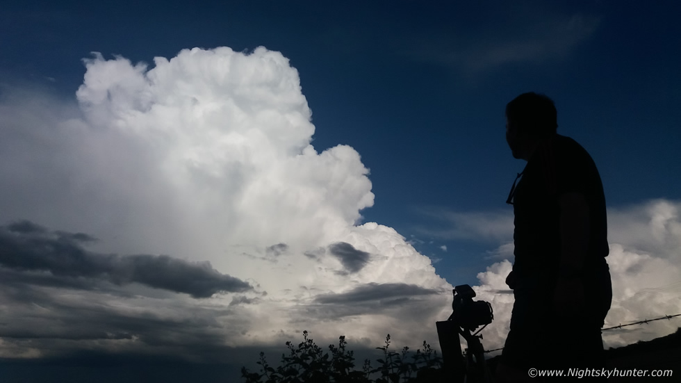 |
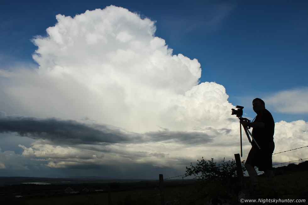
Within five minutes we were looking at a gorgeous young Cumulonimbus erupting with great vigor from its infancy. From our lucky position to the west of the cell we had the picture perfect view of the developing storm's structure while we stood in complete sunshine with not a drop of rain on us, it was a rare prized opportunity which is rarely seen in this country. A rumble of thunder boomed across the landscape and the storm was born and like its predecessor it had explosive updraught development. Owen was on a stone wall with DSLR and lightning trigger back in action, we heard its shutter clicking with increasing frequency, this is a phone snap of Owen and the storm.
 |
Realising this was a rare opportunity not to be missed I mounted the Canon 5D Mark IV with 15mm lens on the tripod, climbed up onto the stone wall, then jumped over a barbed wire fence beside Owen and landed in a nice field which offered an unobstructed view of the storm, I then began shooting a wide angle time lapse. Then back over the wire fence, onto the stone wall, then jumped onto the grass verge below and over to the van, then got the drone in the air once again. I began filming sequences hovering and moving using cruise control, once the drone was performing its task I used my phone to shoot a vlog and extra stills with the Canon 600D while leaning across the roof top of the van while switching lenses between 10mm and 18-55mm.
This was a storm of exquisite beauty, if you know me at all you will know that I'm a cloud structure fan. To me being under the core isn't that interesting, keep in mind you have to be thinking about this from the mind-set of a photographer. The core is great for excitement, especially if you want close lightning and you are getting crazy rainfall or good hail, as thrilling as all this is, it isn't photogenic, unless you are fortunate enough to get a close c-g striking close to you filling the frame of a wide angle lens. For me the real prize catch of storm chasing in N. Ireland is capturing the structure and dramatic clouds, this means staying outside the precip core and being at the rite location at the rite distance to get the perfect perspective.
These viewing circumstances aren't often met during our best Summer thunderstorms, usually we are too near the core, or the road options don't allow us to re-position in time or you can't see the structure at all because the sky is either hazy or there is an abundance of low or mid level cloud obstructing the view. Even if you do get good clear air in Summer, which is rare, the structure might not be worth shooting, or if it is then the sun might be blocked by cloud so you are left shooting dark grey cells. So in order to get the perfect scenario you need a lot of luck, perfect conditions, and a proper organised storm all to happen at the correct distant and with the sun illuminating the clouds, this situation doesn't happen often.
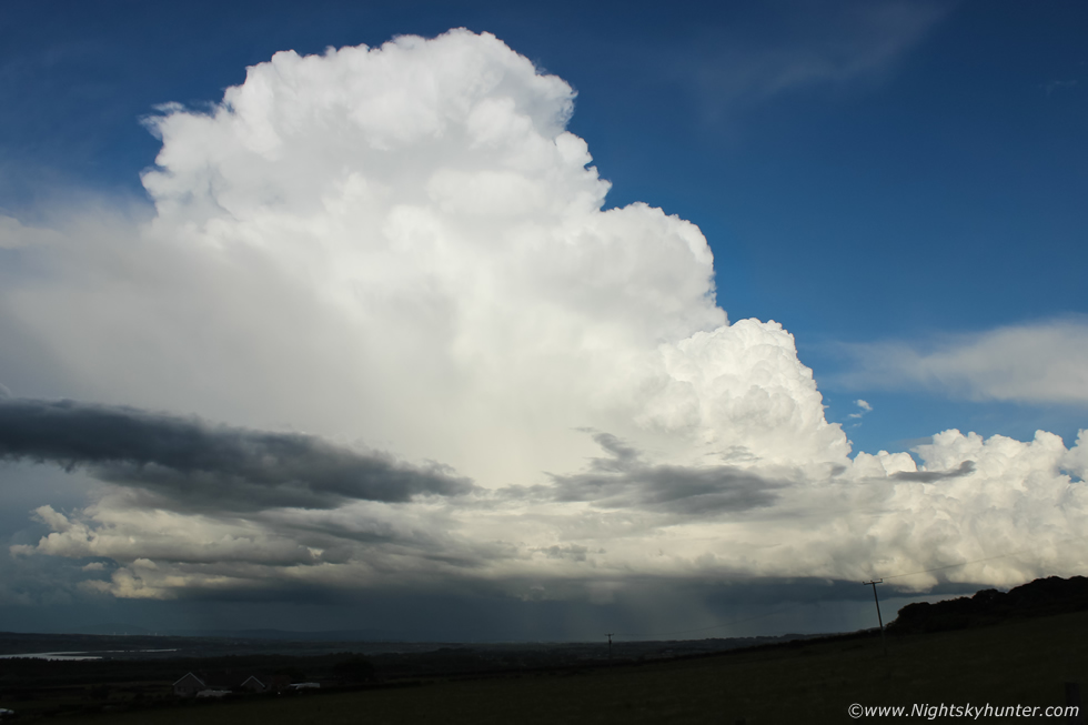
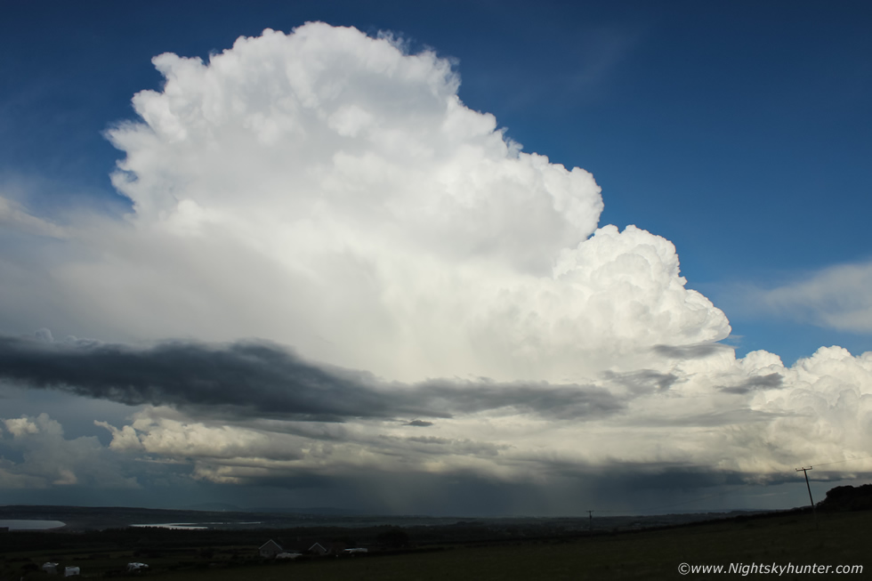
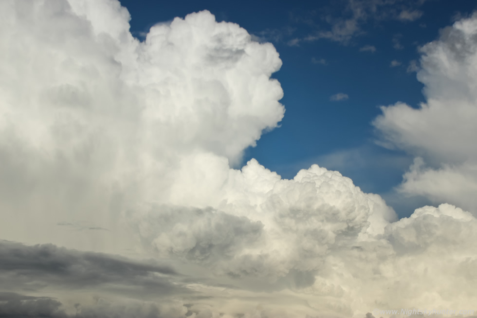
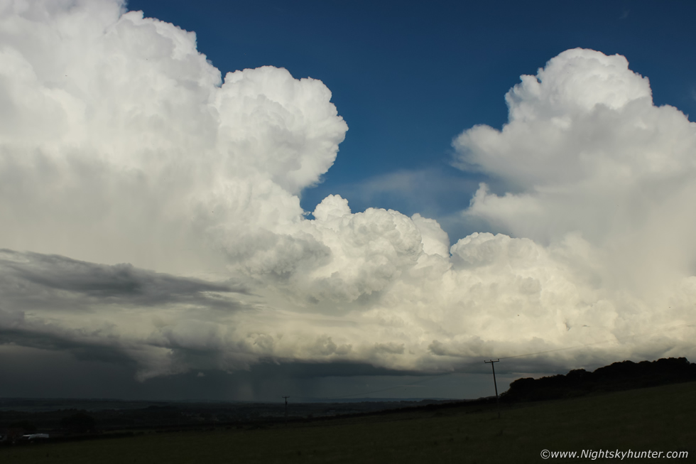
These fleeting set-ups are the moments I chase for, this is one of the main reasons I chase at all, to get this structure and light, and it has to be dramatic enough to take up a large percentage of a wide angle lens. Yet it was all happening rite now and of a caliber far beyond anything I had ever expected. Just look at this gorgeous mountain of ice crystals and water droplets manifesting in the sky from unseen ingredients, ten minutes beforehand this didn't even exist, this was a classic example of explosive thunderstorm development. The core was over Ballymoney and getting sheared NE towards the NE Antrim coast, in this image it's moving from R to L and was completely dominating the sky.
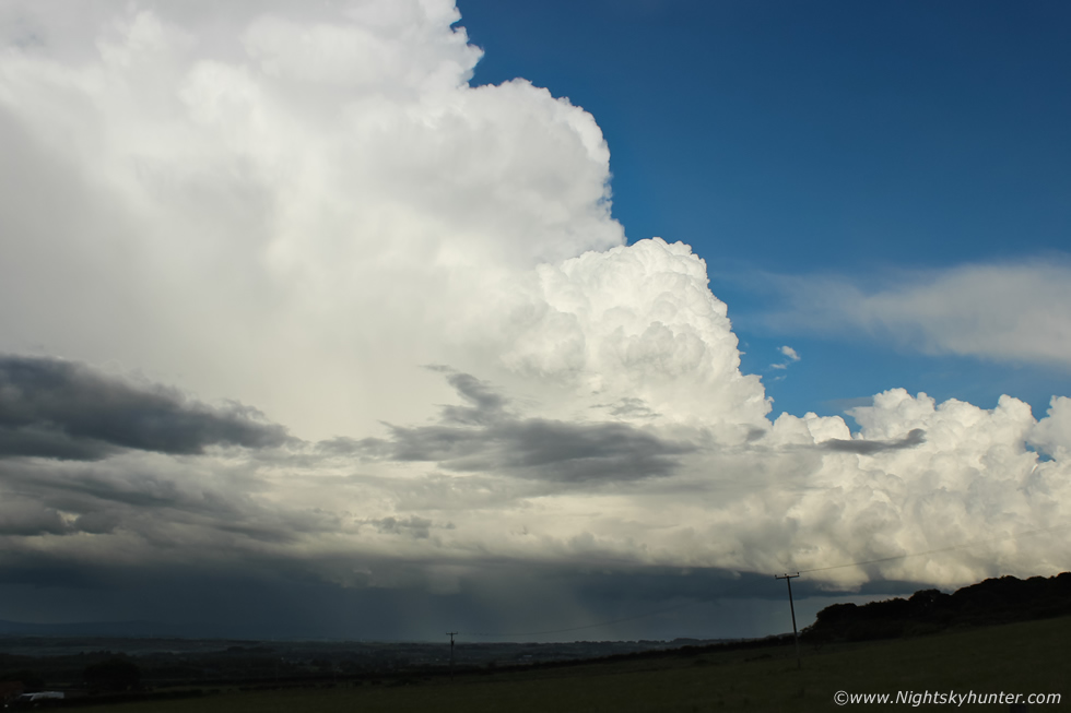 |
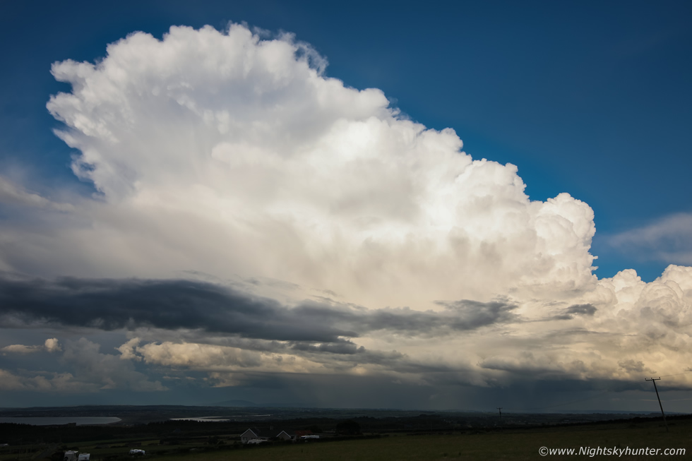
Central updraught with flanking towers filling the wide angle on full frame sensor, what a tremendous sight this was rumbling away in full sunshine with rock sharp cauliflowers boiling against the blue sky in the clear sector. I wish you had been here to witness this with Owen and I, it really is difficult to describe not only the beauty but the shear scale of what was happening, but I promise you if you where here with us this storm would have took your breath away. With the wide angle the top of the frame is almost overhead, I couldn't get the entire structure in despite the cell being 15 miles away.
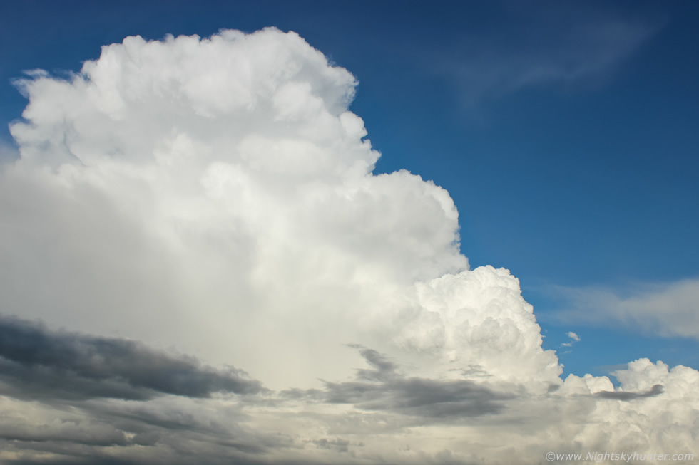 |
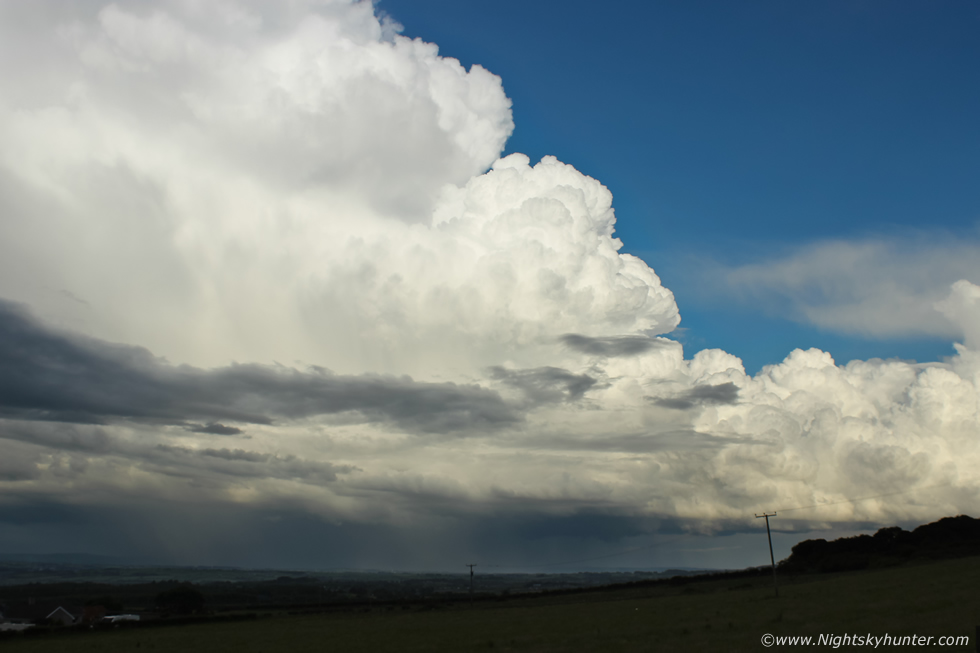
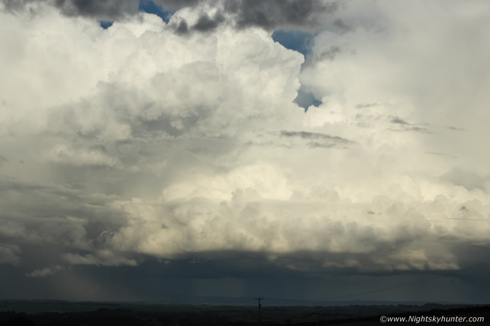
Panning the 15mm wide angle upward to the top of the storm with the classic 'stair step' towers feeding in from the right building in vertical extent into the principle updraught which was now at the top of the Troposphere spreading out into a solid anvil. Thunder rumbled frequently, we couldn't see any bolts however it was obvious from the sound, which seemed to be descending from a great height, that the lightning was intra cloud with many bolts high up within the towers.
 |
Owen said this was the best looking storm he had ever seen, I did a quick mental check of my own best convective moments for comparison. I witnessed great convection during 2009, also 2020, 2014, 2017 and my favourite on August 16th 2012 however it took me a few seconds to agree with 100% certainty that this was the best thunderstorm convection I had ever seen in my life! Not only was the storm spectacular it was also enormous, in fact, it ticked all my boxes, a perfect 10/10. I took this image with the 10mm wide angle with Owen and his DSLR in the frame, a scene I really love because not only does it provide a sense of scale with foreground interest but it was taken in the heat of the moment while Owen was looking at the storm with awe, I know he was buzzing big time and that moment is forever captured here.
 |
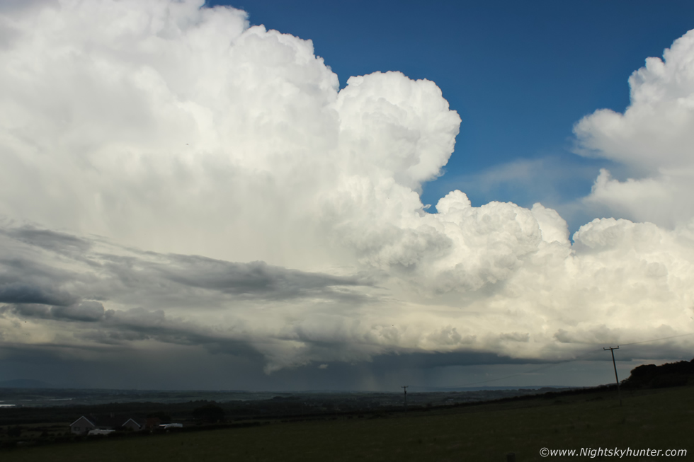
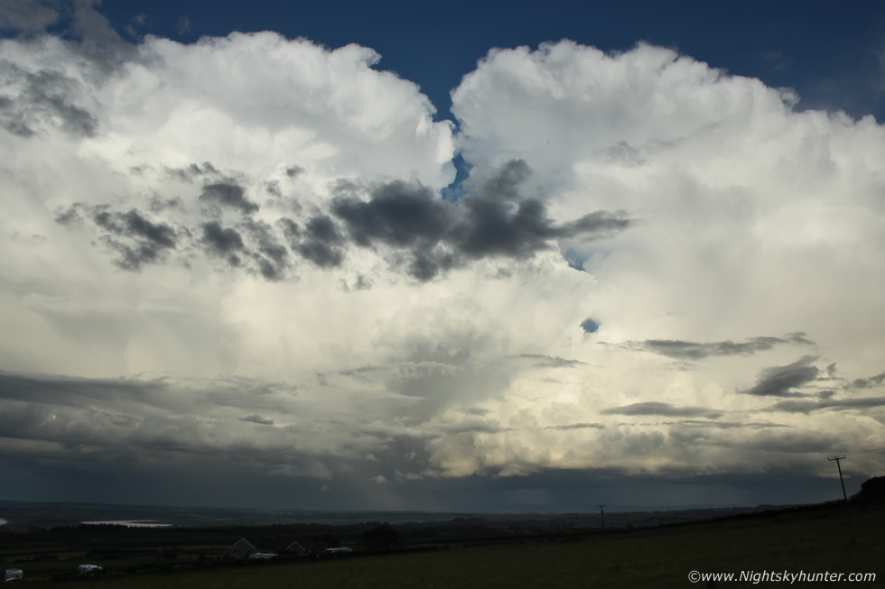
It almost felt like looking at a storm of European standards. Images really don't do it justice as the view in real life was just outrageous, a phrase I kept uttering alot this evening. This really is a text book example of a maturing multicell thunderstorm viewed from the W with the storm in the E moving perpendicular to our line of sight allowing us the privilege of viewing the atmospheric processes in sublime detail. You can imagine the invisible convergence zone in that area, the Nly sea breeze drifting inland and meeting the SWly surface flow. Where these two wind directions meet air is forced to rise (one form of lift) enhancing convective development.
20 knots of wind shear aloft tilts the massive towers over downwind allowing precipitation to fall away from the updraught base allowing the storm to be organised and last longer. As this happens cold outflow from the precipitation core acts like a mini cold front scooping up warm moist unstable air which creates new updraughts along a preferred flank. The result is two or more cells in various stages of evolution all co-existing along this axis, hence the term multicell.
These rapid new updraught formations produced new precipitation and thunder/lightning in a self propagating system which allows the storm complex to exist for so much longer. This semi-automatic updraught formation is referred to as 'back-building' (if at the rear) or 'cell training', for an observer under this complex the results can be flash flooding and multiple rounds of lightning over a very specific area, yet a location a few miles outside this path might be bone dry which was exactly what was going on at this moment in time.
 |
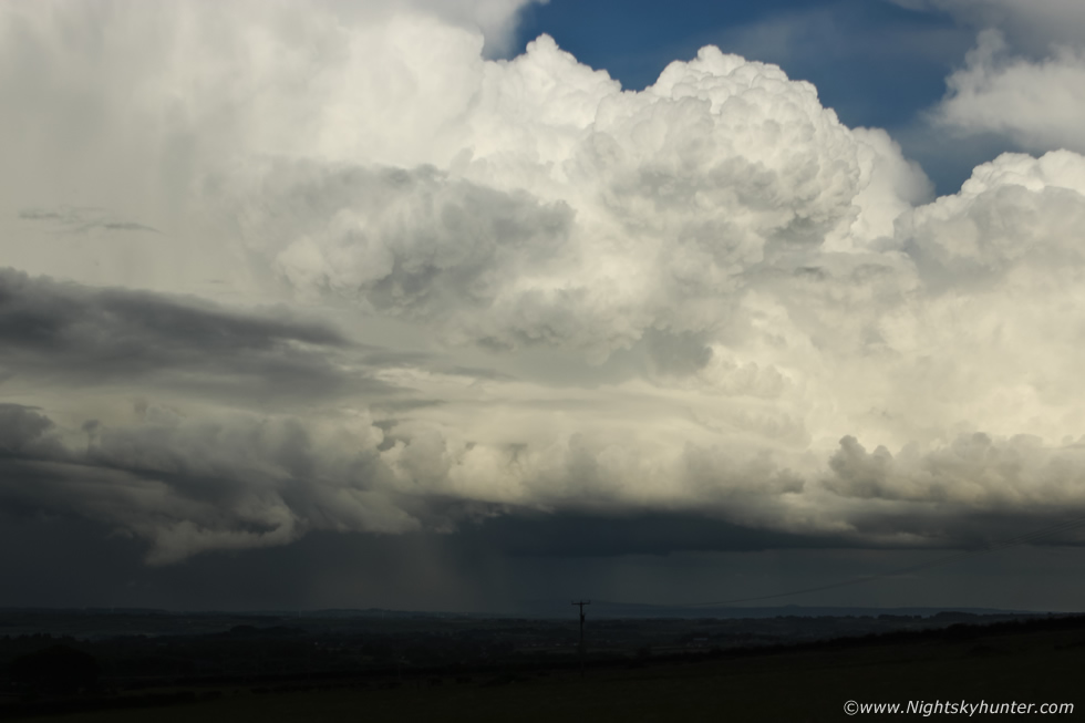
This is the flanking region of the storm or rear of the storm where the growing towers feed into the back of the storm which eventually become mature cells and storms of their own. Flanking lines are best observed on multicell and supercell storms however they are often hidden by cloud so when you do see them in good light they are an absolute treat. Any one of those erupting updraughts is fully capable of producing funnel clouds or weak tornadoes. Take a look at this flanking line, this is very powerful convection taking place, not only is the real time speed dramatic but the cauliflowers have that classic solid look with very crisp edges, a sure sign of significant rising air taking place.
It's really difficult to do these moments justice on camera as they looked far more complex and sharper with the naked eye and of exceptional contrast. I began wondering if Nigel was seeing any of this? he had went home earlier when things looked uneventful, he missed the first storm but surely he was seeing this? I couldn't be sure because of the angle so Owain rang him for a heads up. At first he thought we were joking then when he heard our excited voices he raced outside and began driving in our direction.
 |
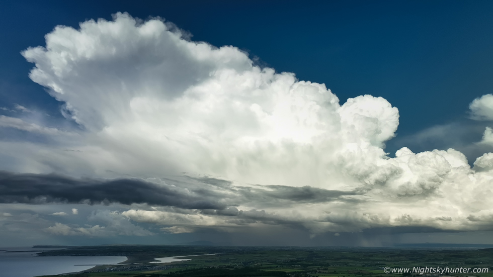
Storm taking up all of the wide angle frame on the Mavic 3 Classic, I will admit I was standing looking at this then looking at the screen on the controller and was awestruck, the immensity, beauty and majesty of this storm was beyond words. I have never seen an entire multicell storm of such size so clearly visible in the late evening sunshine before and I've never seen convection so solid and complex. I was so busy flying the drone and shooting a vlog that I forgot about my DSLR which was still shooting a time lapse in the field, I would check it later, I just hoped the storm was still in the frame.
I already mentioned how rare it was to get this kind of scene but the situation was helped tremendously by the late hour of the day, never before have I seen such a strong multicell less than two hours before sunset, this low sun angle generated great contrast on the convection with white, then warm coloured and shaded knuckles on the updraughts all within the same structure. There was a report from under the storm from Ballymoney saying ''heaviest rainfall seen for a long time, if ever, roads covered in an inch of standing water, thunder every six seconds'' We then heard a vehicle approach us, it was Nigel, finally he arrived just in time to see this storm at its finest. There was also another storm to our NW over Donegal and north coast which was rumbling so once again we where between two storms, a common theme during this exceptional season.
 |
Zooming into the updraughts along the flanking region
 |
This was bloody awesome!, excuse my language, my actual words were a lot more colourful at the time. By the way when something exciting is happening in nature I do tend to get worked up and can get quite emotional with joy, this can often take on the form of cursing, there's no excuse for it but sometimes I just can't keep my composure, and besides, no words can help me vent what I was feeling, you sometimes just have to come out with it. So if you are ever beside me when I'm in this mind-set pass no remarks and don't take offense, it's just me being very happy and in my element. To me this isn't far away from USA standards, Owen himself described it was ''continental quality''. That storm just kept going up out of frame to the upper left far above, keep in mind this is still with the wide angle lens. When I look back on this now I was kicking myself, I should have set up my 600D in the field beside the 5D and shot another time lapse zoomed into these towers, but I had too much going on with the drone and vlog that I couldn't cover everything.
 |
I let the drone hover 100m in altitude and filmed several uninterrupted video sequences which I was then able to speed up to make a time lapse, the Mavic 3 was so steady you would almost think it was mounted on a tripod. This is a still frame taken from the video showing the entire storm in the wide angle aerial camera with massive anvil and sporting the most spectacular flanking line convection I've ever seen. I actually used the unedited drone footage to make a relaxation video (below) where you can watch the storm develop in real time with no editing at all with the intention of portraying a moment of tranquility.
 |
I'm a storm structure guy so my cameras always get pointed at the updraught/base/flanking region where all the dramatic inflow action is taking place, this is also the location to capture funnel clouds and tornadoes, which brings up a good point, how on Earth did this thing not produce a funnel? that's beyond me, maybe that would just be asking for too much, perhaps Mother Nature doesn't want to reveal all her glory on the same day. I can just imagine a long white curving rope funnel from that base, that would be a truly epic moment, but I'm not in the slightest bit annoyed, this structure alone has not only made my chase year but perhaps will make up for many years to come.
 |
Another thunderstorm was rumbling over Donegal and the Atlantic to our left, Nigel and Owain were almost unsure where to point their cameras, they began taking turns trying out both. During one lucky moment we glanced straight ahead at the Ballymoney/Ballycastle storm and witnessed two brilliant c-gs striking the ground, they looked to have been just outside the precip core in clear air on our sunlit side, they were amazing, I suspect that one or both may have been positive bolts.
 |
Another super wide angle 15mm view of the flanking line for good measure, another big updraught had shot up on the south end of the line and was already in the process of forming a young anvil.
 |
Amazing structure along this new updraught base which looked substantial with a bulging almost rounded look complimented with an artillery of convective updraughts adorned with knuckles.
 |
Same scene at 15mm moments later with two enormous storms side by side rumbling away. Check out the anvil on the lead cell (left), it's been a long time since I've seen an anvil so thick and solid in years and for a time this one had a back-sheared aspect. After what seemed a long time the storms moved away into the distance and over the NE coast and across the ocean. Nigel, Owen and I just stood there buzzing in the late evening sunshine.
It was after 21.00 and we were still warm and humid and midgets were starting to bite, there was no air at all. My last memory was seeing the leading edge of the primary anvil in clear air catching the warm pre-sunset light far out to sea. This thunderstorm was so special to me that I honestly could have stayed on that coastal road looking at the sky all night long, I didn't want to break this magical moment and I'm sure the other guys felt the same way. I will say again, I've seen some brilliant storms and convection before over the last 20 or more years of chasing and storm photography in N. Ireland but this was hands down the most spectacular, immense, most beautiful and majestic thunderstorm I've ever seen in my life.
As the adrenaline began to ease tiredness took over, I also felt dehydrated, all our water was used up and Rhua was thirsty too so I said goodbye to the guys, who where still standing on the road, got fresh water from a shop and began the 1.5 hour drive home. It's always an easy drive back from anywhere when you know you have something cool on camera. During the drive back the sun had set yet I could still see two distant cells over the Sperrins with their dark forms against the dusk sky showcasing their anvils with mammatus, this was the perfect end to an unforgettable day.
Full chase vlog covering the early part of the day explaining my intentions and instincts about the coast, the mid afternoon uninspiring convection then the surprise multicell storms which made the day. This is a combination of DSLR time lapse, phone footage and drone footage, I hope in some way this video captures the majesty of those remarkable structures.
Relaxation video showing unedited real time drone footage of the Ballymoney cell where you can sit back and enjoy a tranquil experience watching a thunderstorm grow and evolve, the background thunder complimenting the audio was recorded by Owain Rice from Co. Down from real thunderstorms over that same period. Thanks very much for reading, I'm still buzzing as I think about these storms 21 days later!
Martin McKenna
